@DeletedUser40638253 (talk | contribs) m (→Gallery) |
m (Protected "Navezgane": Primary page set to auto confirmed edits only ([Edit=Allow only autoconfirmed users] (indefinite) [Move=Allow only autoconfirmed users] (indefinite))) |
||
| (45 intermediate revisions by 26 users not shown) | |||
| Line 1: | Line 1: | ||
| − | {{stub}} |
||
{{Infobox locations |
{{Infobox locations |
||
|name = Navezgane |
|name = Navezgane |
||
|image = Navezgane map thumbnail.jpg |
|image = Navezgane map thumbnail.jpg |
||
| − | |size = |
+ | |size = 350px |
|caption = Navezgane Map Thumbnail |
|caption = Navezgane Map Thumbnail |
||
|category = Game World |
|category = Game World |
||
| + | |navezgane = 1 |
||
| + | |confirmed_version = Alpha 15 |
||
| + | |added_version = Alpha 1 |
||
| + | |updated_version = Alpha 15 |
||
|}} |
|}} |
||
| − | '''{{PAGENAME}}''' County Arizona, a "rare Eden in a world of devastation", is the main location in ''[[7 Days to Die]]''. |
+ | '''{{PAGENAME}}''' County Arizona, a "rare Eden in a world of devastation", is the main location in ''[[7 Days to Die]]''. In the Apache language, “Navezgane” means "Killer of Monsters." The Navezgane map covers an area of 32 km<sup>2</sup> with 100 meters of highly irradiated area surrounding the edges of the map. Unlike the randomly generated maps, the Navezgane map will not continue to generate once the border is reached. |
| + | The northern half of Navezgane contains the less brutal biomes. It is recommended to start a base in the area north of Navezgane's Burnt Forest biome, which separates it from the harsher biomes to the south. |
||
| ⚫ | |||
| + | |||
| ⚫ | |||
| ⚫ | |||
| ⚫ | |||
| + | ===Biomes=== |
||
* [[Burnt Forest]] |
* [[Burnt Forest]] |
||
| − | * [[City|Cities]] - <small>Contain the most amount of zombies in the map. Cities have many useful resources such as weapons, tools and food and water.</small> |
||
* [[Desert]] |
* [[Desert]] |
||
| ⚫ | |||
| − | * [[Forest]] - <small>Contain an abundance of trees and wildlife. There are fewer zombies in the forest than in the city.</small> |
||
| − | * [[Nuclear Fallout Zone]] - <small>These serve as a barrier preventing the player from going off-map.</small> |
||
| ⚫ | |||
* [[Plains]] |
* [[Plains]] |
||
| ⚫ | |||
* [[Snowy Forest]] |
* [[Snowy Forest]] |
||
* [[Wasteland]] |
* [[Wasteland]] |
||
| + | |||
| + | ===Areas=== |
||
| + | * [[City|Major Cities]] |
||
| + | **[[Gravestown]] |
||
| + | **[[Diersville]] |
||
| + | **[[Perishton]] |
||
| + | **[[Departure]] |
||
| + | * [[Town|Minor Town]]s |
||
| + | ** [[Trailer Park]] |
||
| + | ** Old Western Town |
||
| ⚫ | |||
| + | * [[Wilderness]] |
||
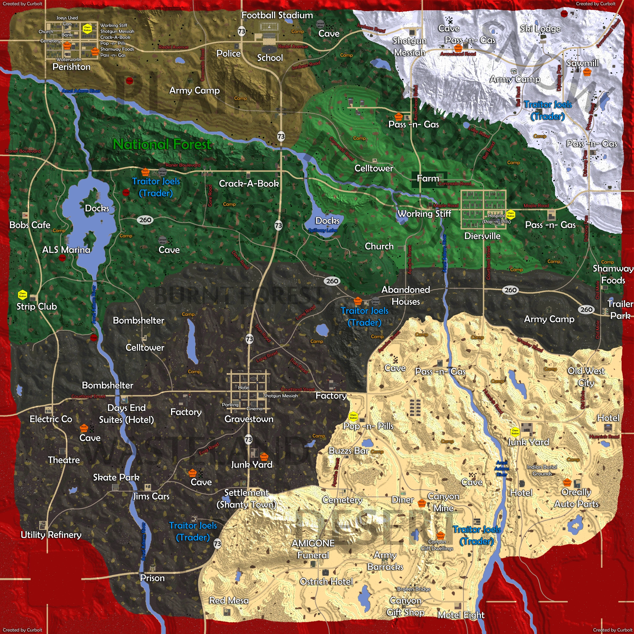
==Points of Interest== |
==Points of Interest== |
||
| − | {{PAGENAME}} has many [[ |
+ | {{PAGENAME}} has many [[Points of Interest]], some of which are exclusive to {{PAGENAME}}. |
| + | Most points of interest have a [[Prefabs|Prefab]] to go along with them. |
||
| − | Such an example would be the big national park which is located near the southern Street 73, west of the Spillway lake. |
||
| + | See [[List of Locations]] for a list of all locations that can be found in {{PAGENAME}}. |
||
| + | == Video not updated to Alpha 19 == |
||
| − | |||
| − | == Video == |
||
{{#ev:youtube|SK0cre9uzKE}} |
{{#ev:youtube|SK0cre9uzKE}} |
||
| + | ==Map== |
||
| + | |||
| + | === Alpha 19 Map === |
||
| + | ''Hint: Click on the image to enlarge.'' |
||
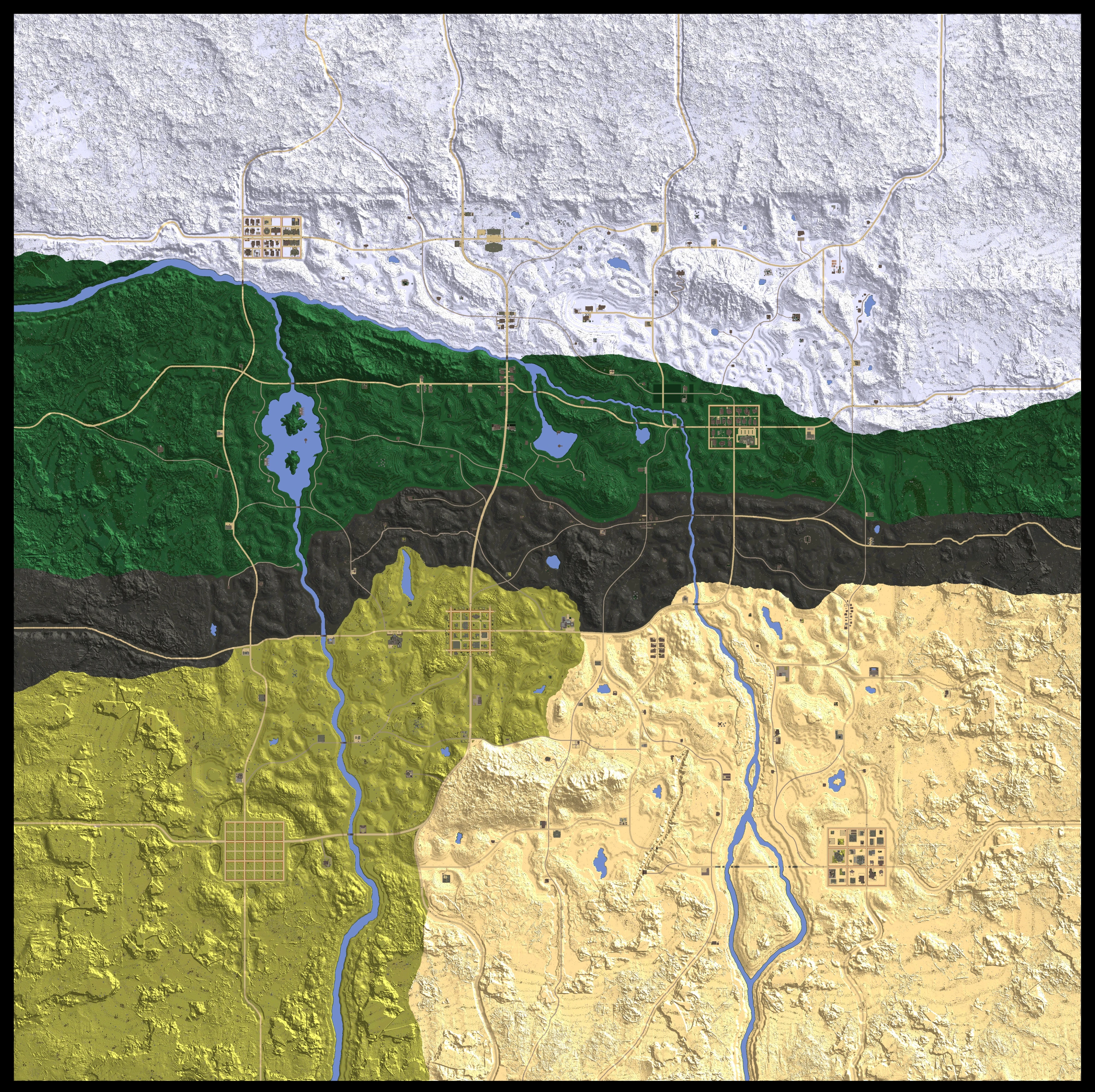
| + | [[File:Navezgane A19.jpg|alt=Alpha 19 by Curbolt|thumb|600x600px|none]]<br /> |
||
| + | |||
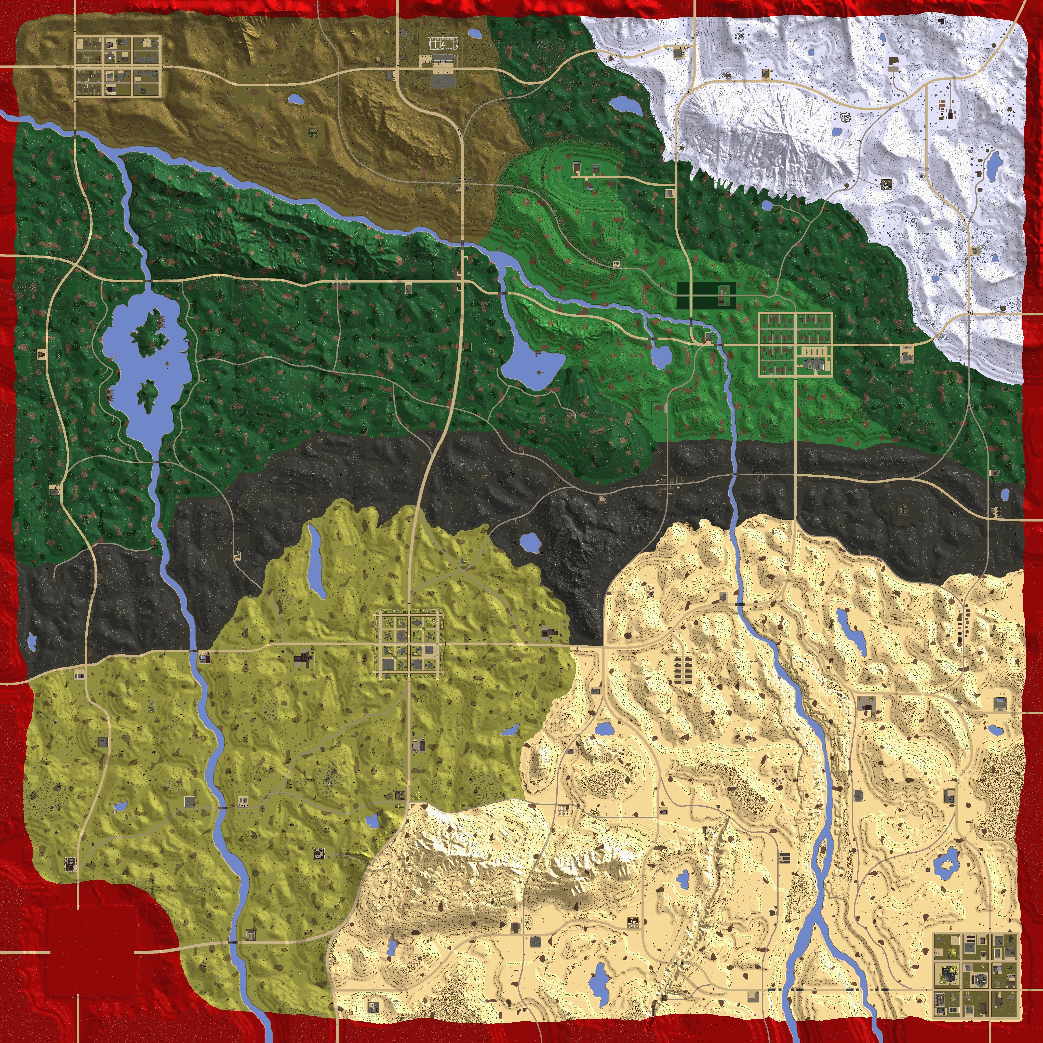
| + | === Alpha 19 Trader Locations Map === |
||
| + | ''Hint: Click on the image to enlarge.'' |
||
| + | [[File:A19 TraderMap.png|alt=Alpha 19 Trader Locations by Tesfallout|thumb|600x600px|none]]<br /> |
||
== Gallery == |
== Gallery == |
||
<gallery widths="200"> |
<gallery widths="200"> |
||
| + | File:Navezgane A19.jpg|alt=Navezgane Alpha 19 map by Curbolt|Navezgane Alpha 19 map by Curbolt |
||
| ⚫ | |||
| − | + | File:Navezgane A17 B197 by Curbolt.jpg|Navezgane A17 B197 by Curbolt |
|
| − | Navezgane |
+ | File:Navezgane A16 B105 by Curbolt.jpg|Navezgane A16 B105 by Curbolt |
| − | Navezgane |
+ | File:Navezgane A15 B105 Fullmap Names Roads 2k by Curbolt.png|Navezgane A15 B105 Full Map with Names & Roads by Curbolt |
| − | Navezgane |
+ | File:Navezgane-Map-Alpha-15-2K.jpg|Navezgane Alpha 15 by dwdotco. |
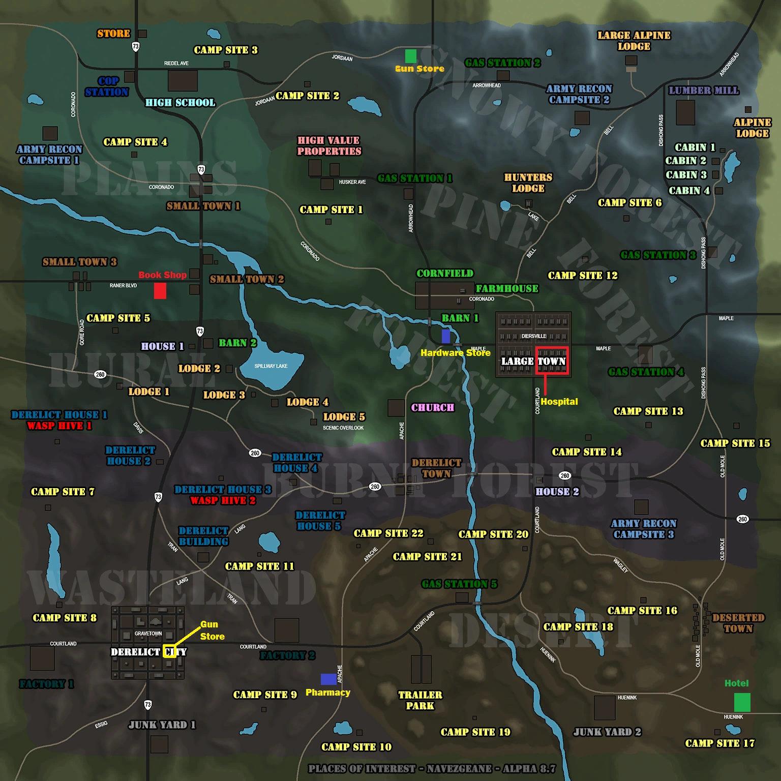
| + | File:Navezgane-map alph thirteen.png|Navezgane Alpha 13 all locations + points of interest |
||
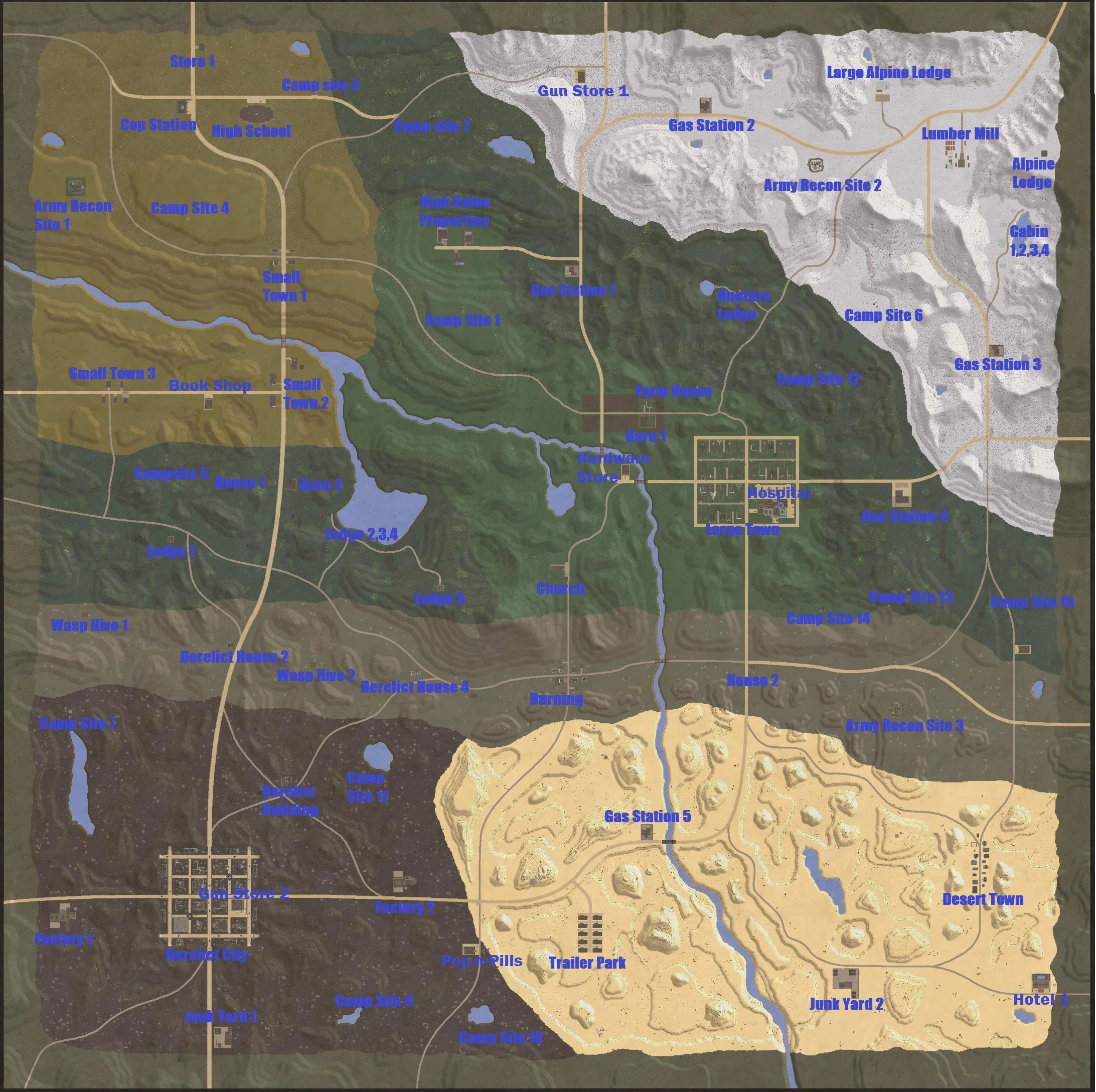
| + | File:15LL3qC - Imgur.jpg|Navezgane Alpha 12 all locations marked |
||
| ⚫ | |||
</gallery> |
</gallery> |
||
| + | ==Trivia== |
||
| + | *The real-world Arizona State Routes [[wikipedia:Arizona State Route 73|73]] and [[wikipedia:Arizona State Route 260|260]] pass through Navezgane. Based on this and on the distances shown on the destination road-signs, Navezgane would be located near the town of [[wikipedia:Whiteriver, Arizona|Whiteriver, Arizona]] and the surrounding [[wikipedia:Fort Apache Indian Reservation|Fort Apache Indian Reservation]]. |
||
| + | |||
| + | ==See also== |
||
| + | *[[Random World Generation]] |
||
| + | *[[Map]] |
||
| + | |||
| + | [[Category:Navezgane]] |
||
[[de:Navezgane]] |
[[de:Navezgane]] |
||
[[es:Navezgane]] |
[[es:Navezgane]] |
||
Revision as of 06:30, 27 February 2021
| Navezgane | |
|---|---|
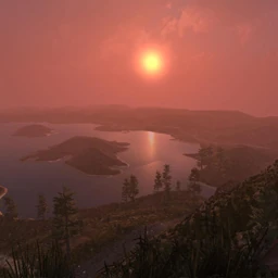 Navezgane Map Thumbnail | |
| Description | |
| Category | Game World |
| Game Worlds
| |
| Navezgane | Yes |
Navezgane County Arizona, a "rare Eden in a world of devastation", is the main location in 7 Days to Die. In the Apache language, “Navezgane” means "Killer of Monsters." The Navezgane map covers an area of 32 km2 with 100 meters of highly irradiated area surrounding the edges of the map. Unlike the randomly generated maps, the Navezgane map will not continue to generate once the border is reached.
The northern half of Navezgane contains the less brutal biomes. It is recommended to start a base in the area north of Navezgane's Burnt Forest biome, which separates it from the harsher biomes to the south.
Biomes & Areas[]
Navezgane contains many different Biomes and areas.
Biomes[]
Areas[]
- Major Cities
- Minor Towns
- Trailer Park
- Old Western Town
- Rural Areas
- Wilderness
Points of Interest[]
Navezgane has many Points of Interest, some of which are exclusive to Navezgane.
Most points of interest have a Prefab to go along with them. See List of Locations for a list of all locations that can be found in Navezgane.
Video not updated to Alpha 19[]
Map[]
Alpha 19 Map[]
Hint: Click on the image to enlarge.


Alpha 19 Trader Locations Map[]
Hint: Click on the image to enlarge.
Gallery[]

Navezgane Alpha 19 map by Curbolt

Navezgane A17 B197 by Curbolt

Navezgane A16 B105 by Curbolt

Navezgane A15 B105 Full Map with Names & Roads by Curbolt
Navezgane Alpha 15 by dwdotco.
Navezgane Alpha 13 all locations + points of interest
Navezgane Alpha 12 all locations marked
Navezgane Alpha 11.1
Trivia[]
- The real-world Arizona State Routes 73 and 260 pass through Navezgane. Based on this and on the distances shown on the destination road-signs, Navezgane would be located near the town of Whiteriver, Arizona and the surrounding Fort Apache Indian Reservation.